

Best Management Practice Fact Sheet 16: Step Pool Stormwater Conveyance
ID
BSE-341P
What is Step Pool Stormwater Conveyance?
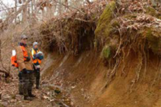
In urban areas, stormwater is directed into a stormwater conveyance system, which can include pipes, swales, or ditches. Often, pipes are the chosen method for conveying larger runoff flows in urban areas. When one of these pipes discharges at the top of a steep slope, concentrated flow can cause extensive erosion, creating deep gullies along the slope (see Figure 1). These gullies become a source of sediment and associated nutrients or other pollutants to receiving streams. The gullies can also become deep enough to intercept the water table, which, in turn, lowers local groundwater levels.
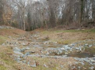
Step Pool Stormwater Conveyances (SPSCs), also known as Coastal Plain outfalls or regenerative stormwater conveyances, are used to convey runoff from developed areas to streams, reducing erosion, improving stormwater quality, and recharging shallow groundwater. SPSCs direct runoff into a series of pools with beds (see Figure 2) composed of a permeable, sand-based filter media similar to that found in rain gardens and bioretention cells.
How Does Step Pool Stormwater Conveyance Work?
On steep slopes, rock weirs are spaced across the channel, perpendicular to the flow direction at pre- determined distances downslope, creating a series of shallow pools that slow stormwater and reduce erosion. These rock weirs are designed to mimic the rocks and logs found in naturally occurring step-pool channels. The step-pool channel morphology of steep SPSCs dissipates flow energy during storm events, and the pool beds filter and absorb water during low flow conditions.
Where Can Step Pool Stormwater Conveyance be Used?
SPSCs are effective for either first-order streams or eroded gullies with intermittent flows with valley and channel slopes between 2% and 10%. SPSCs with a slope greater than 5% will generally provide fewer water quality benefits than those on gentler slopes, so they should be avoided unless absolutely necessary, and should only be undertaken by an experienced designer. While an SPSC may be designed for a site with a valley or channel slope greater than 10%, these applications should be used with caution, and the design should be modified (e.g., by reinforcing the rock weirs) to compensate for the increased hydraulic forces that will result.
Potential Advantages
- Can be used in a wide variety of locations if properly designed.
- Prevents erosion and subsequent increased downstream sediment pollution.
- Retains woody debris, which facilitates pollutant removal processes such as denitrification.
- Retains a wide range of aggregates, which are needed to form stable channels.
- Reconnects the stream with the floodplain and the water table.
- Facilitates establishment of vegetation.
- Fosters the creation of both aquatic and terrestrial habitat (MDNR 2018).
Potential Limitations
- It is a relatively new best management practice (BMP), so design and maintenance experience is limited.
- Water quality credits are based upon relatively few studies. Information on crediting will improve as more SPSCs are implemented and monitored.
How are Step Pool Stormwater Conveyances Designed and Built?
General Design Guidelines
Although the SPSC is technically a constructed or modified channel, it should be designed to minimize alterations to the receiving stream and surrounding habitat. By constructing the SPSC in an existing first- order stream or erosion gully, runoff can continue to be discharged into the receiving stream at the same location, but with less energy. Designs should be modified on a site-by-site basis, depending on what is required to fit the SPSC within the existing channel, while ensuring the SPSC can convey the peak flow rate from a 100-year storm without causing scour of the weirs. Because the 100-year storm recurs relatively infrequently and most stormwater drainage systems are designed to only handle flows from 10-year or 25-year storms, this approach results in a conservative design. It is also important that the SPSC be connected to the receiving stream in a way that minimizes the potential for a knickpoint to form on the floodplain at the SPSC outlet, which could potentially undermine the SPSC. Because SPSCs can involve construction in a waterway, a permit from local and state agencies or the U.S. Army Corps of Engineers will likely be required prior to construction.
At its most basic level, an SPSC is a modified channel consisting of pools alternating with steps or cascades. Steps are constructed of large boulders and cobbles (see Figure 3) and have drops of no more than 1 foot, where a drop is the elevation difference between the low points on two consecutive weirs. Cascades are larger structures that can have drops up to 5 feet. The rock weirs are constructed in a shallow parabola that opens downstream, such that the arms of the weir form 70 degree angles with the bank. This shape will direct flows towards the center of the SPSC channel.
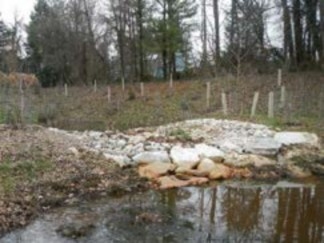
Pools are located between steps or cascades and should be at least 10 feet long and more than twice the length of the preceding rock weir or cascade to dissipate energy. Pools that are wider than they are long (length: width <1) and at least 1.5 feet deep provide better energy dissipation (Thompson, Hathaway, and Schwartz 2018).
If the stream to which the SPSC discharges is incised, it is recommended that a riffle grade control be installed in the receiving stream to provide a stable outfall for the SPSC and to limit the potential development of a knickpoint at the downstream end of the SPSC or within the channel. If the receiving stream is actively eroding, a rock weir may need to be placed in the receiving stream to further dissipate the SPSC flow energy.
Construction
Material selection and sizing for the SPSC is largely dependent on the requirements that the rock weirs and channel remain structurally stable during the design flow while also creating the required weir and pool geometry. The peak stream flow rate from the 100-year storm event is used for the weir design and material sizing. Detailed design guidance is available from the Anne Arundel County Department of Public Works (Anne Arundel Bureau of Engineering 2012). When selecting materials for the various SPSC components (rock weirs, pool beds, and vegetation), it is important to select materials that will not affect water chemistry or clog the sand filtration media.
Filtration media should be placed in the pools for shallow groundwater recharge primarily using locally sourced sand. Where water quality benefits are a project goal, a sand-woodchip filtration media mixture similar to those used in bioretention cells should be used, with an estimated 20% woodchip content by volume. Where water quality benefits are not a project goal, native soil with a comparable infiltration rate may be left in place instead, as long as the design guidelines are still met.
Construction of the SPSC should begin at the outlet and progress upstream. If sedimentation and clogging of the SPSC beds occur due to upstream construction, the affected pools should be scraped clean of fine sediment and vegetation at the completion of the overall project.
Filter fabric should be placed beneath weir footer rocks to ensure that rock weirs will not fail by winnowing or undercutting. Filter fabric must not extend beneath the pools, or it will interfere with filtration and infiltration functions. Wood mulch should be used on the side slopes of the SPSC for erosion protection if construction does not take place during a planting season. Invasive and nonnative vegetation should be removed from the site before planting.
Post Construction Monitoring and Maintenance
It is recommended that routine post-construction monitoring be conducted for at least three years with periodic inspection thereafter as part of a regular stormwater management program. Corrective action should be taken if and when problems arise. Some monitoring and maintenance activities to ensure that the SPSC functions as intended include the following:
- Monitor pool depth to ensure the pools are not aggrading or degrading, and remove accumulated sediments or replace the filter bed media as necessary to maintain infiltration.
- Examine the SPSC vegetation to ensure that establishment is sufficient for erosion prevention, and replant or reseed vegetation as needed.
- Regularly examine the surrounding slopes for erosion, particularly where the weirs meet the surrounding slopes; extend the rock weirs higher on surrounding slopes if erosion of the adjacent slopes occurs due to flow around the rock weirs.
- Regularly examine the weirs for rock displacement after large flow events and replace them if necessary.
- Regularly examine the receiving stream for aggradation or degradation caused by the SPSC structure and reinforce the receiving stream if channel erosion occurs.
Consider requesting help from local conservation or volunteer-based organizations for monitoring work that can be performed by laypeople if resources for monitoring are scarce.
Performance
Since SPSCs are new and the complex surface and subsurface flows are difficult to monitor, only a limited amount of scientific, peer-reviewed performance data are available. A study of an SPSC in the North Carolina Coastal Plain measured a median decrease in runoff volume and peak flow rate of 78% and 76%, respectively, over an 11-month period (Cizek et al. 2018). This study also documented median load reductions of 86%, 83%, and 93% of total nitrogen, total phosphorus, and total suspended solids in surface runoff, respectively, largely due to decreases in surface runoff volumes. Because SPSCs are designed to promote the infiltration and slow release of runoff, the pollutant load reductions will likely be lower when the overall system is considered (Cizek et al. 2018). Koryto et al. (2018) measured runoff and nutrient load reductions in both surface and subsurface flows in a scaled experimental SPSC in Raleigh, North Carolina. Surface flow runoff volumes were reduced by 80% during a 1-inch, 24-hour design storm and by 40% during a 1.5-inch, 24-hour event. Median total nitrogen (TN) and total phosphorus (TP) load reductions were 46% and 68% for the 1-inch storm event and 20% and 33% for the 1.5-inch storm event. However, SPSCs installed on steep slopes (>5%) or where there is a high water table may have limited runoff reduction and/or water quality benefits (Koryto, Hunt, and Page 2017; Thompson, Schwartz, and Hathaway 2020).
Several recommendations are available on how to estimate the amount of pollutants removed by SPSC systems. Berg et al. (2014) provides a method for estimating SPSC sediment and nutrient removal credits based upon retrofit curves. In contrast, WVDNR (2012) suggests a runoff volume reduction equal to the design volume of the practice, based upon a 1-inch water storm event, which results in a 90% total suspended solids (TSS) credit. A total nitrogen credit of 74% and a total phosphorus credit of 76% were also recommended based upon an assumption of performance similar to that of a Level 2 dry swale. Since this is an innovative practice with limited performance history, water quality credits should be assessed on a site-by-site basis.
Expected Cost
Costs for SPSC systems are typically $500 to $750 per linear foot, depending on the amount of excavation or fill required to install the system (E. Michelsen, personal communication, Dec. 9, 2019).
Additional Information
The Virginia departments of Conservation and Recreation (VA-DCR) and Environmental Quality (VA- DEQ) are the two state agencies that address nonpoint source pollution. The VA-DCR oversees agricultural conservation; VA-DEQ regulates stormwater through the Virginia Stormwater Management Program.
A wide variety of information on various BMPs can be found at the Virginia Stormwater BMP Clearinghouse website at https://www.swbmp.vwrrc.vt.edu/. The BMP Clearinghouse is jointly administered by VA-DEQ and the Virginia Water Resources Research Center. Since this practice is new, it has not yet been reviewed and placed on the Clearinghouse site. However, a review was conducted by an Expert Panel of the U.S. EPA Chesapeake Bay Program (Berg 2014). Performance information contained in this document is tentatively given based upon these and other cited sources, but verification is recommended.
Online Resource
Step Pool Conveyance Systems, Anne Arundel County, Maryland https://www.aacounty.org/departments/public-works/wprp/watershed-assessment-and-planning/step-pool-conveyance-systems/
Companion Virginia Cooperative Extension Publications
Gilland, T., L. Fox, and M. Andruczyk. 2018. “Urban Water-Quality Management — What Is a Watershed?” VCE Publication 426-041. https://resources.ext.vt.edu/contentdetail?contentid=1464.
Sample, D. J., L. J. Fox, and C. Hendrix, 2020. “Urban Stormwater: Terms and Definitions.” VCE Publication 426-119. https://resources.ext.vt.edu/contentdetail?contentid=2810.
Sample, D.J., Fox, L.J., and Hendrix, C., 2020. Dry Swale, BMP Fact Sheet #10 (VCE Pub. 426-129. https://resources.ext.vt.edu/contentdetail?contentid=2140
Acknowledgements
Funding was provided by the Maryland Department of Natural Resources, the U.S. Environmental Protection Agency, and the Chesapeake Bay Trust. The authors thank Erik Michelsen, Anne Arundel County Department of Public Works, for reviewing a prior version of this document. The authors thank the reviewers of this fact sheet, including Cully Hession, Professor, Biological Systems Engineering; Jon M. Hathaway, Civil and Environmental Engineering, University of Tennessee – Knoxville; and Mikel A. Manchester, Agriculture and Natural Resources and Water Quality Extension Agent, Fredericksburg, Virginia. Their thoughtful comments resulted in a much-improved document.
References
Anne Arundel Bureau of Engineering. 2012. “Design Guidelines for Step Pool Storm Conveyance.” Department of Public Works, Anne Arundel County, MD.
https://www.aacounty.org/departments/public-works/wprp/forms-and-publications/SPSCdesignguidelinesDec2012Rev5a.pdf. 36 pages.
Berg, J., J. Burch, D. Cappuccitti, S. Filoso, L. Fraley- McNeal, D. Goerman, N. Hardman, S. Kausahl, D. Medina, M. Meyers, B. Kerr, S. Stewart, B. Sullivan, R. Walter, and J. Winters. 2014. “Recommendations of the Expert Panel to Define Removal Rates for Individual Stream Restoration Projects.” U.S. Environmental Protection Agency Chesapeake Bay Program.
http://chesapeakestormwater.net/wp-content/uploads/dlm_uploads/2013/10/stream- restoration-short-version.pdf. 64 pages.
Chin, A., S. Anderson, A. Collison, B. J. Ellis-Sugai, J. P. Haltiner, J. B. Hogervorst, G. M. Kondolf, L. S. O’Hirok, A. H. Purcell, A. L. Riley, and E. Wohl. 2009. “Linking Theory and Practice for Restoration of Step-pool Streams.” Environmental Management 43(4): 654-661.
https://doi.org/10.1007/s00267-008-9171-x.
Cizek, A. R., W. F. Hunt, R. J. Winston, S. E. Waickowski, K. Narayanaswamy, and M. S. Lauffer. 2018. “Water Quality and Hydrologic Performance of a Regenerative Stormwater Conveyance in the Piedmont of North Carolina.” Journal of Environmental Engineering (United States), 144(8): 1–11. https://doi.org/10.1061/(ASCE)EE.1943-7870.0001344.
Koryto, K. M., W. F. Hunt, and J. L. Page. 2017. “Hydrologic and Water Quality Performance of Regenerative Stormwater Conveyance Installed to Stabilize an Eroded Outfall.” Ecological Engineering, 108: 263–276. https://doi.org/10.1016/j.ecoleng.2017.04.041.
Koryto, K. M., W. F. Hunt, C. Arellano, and J. L. Page. 2018. “Performance of Regenerative Stormwater Conveyance on the Removal of Dissolved Pollutants: Field Scale Simulation Study.” Journal of Environmental Engineering, 144(6): 1–13.
https://doi.org/10.1061/(ASCE)EE.1943-7870.0001374.
MDNR (Maryland Department of Natural Resources). 2018. Regenerative Stream Conveyance: Construction Guidance. https://dnr.maryland.gov/ ccs/Documents/RSC_Training/RSC-Guidance.pdf. 78 pages.
Thompson, J. M., J. M. Hathaway, and J. S. Schwartz. 2018. “Three-dimensional Modeling of the Hydraulic Function and Channel Stability of Regenerative Stormwater Conveyances.” Journal of Sustainable Water in the Built Environment, 4(3): 1–12.
https://doi.org/10.1061/JSWBAY.0000861.
Thompson, J., J. S. Schwartz, and J. M. Hathaway. 2020. “Performance Evaluation of a Regenerative Stormwater Conveyance System: Case Study in Knoxville, Tennessee.” Journal of Environmental Engineering, 146(7): 1–7. https://doi.org/10.1061/(ASCE)EE.1943-7870.0001744.
WVDNR (West Virginia Department of Environmental Protection). 2012. West Virginia Stormwater Management and Design Guidance Manual. Prepared by the Center for Watershed Protection.
http://dep.wv.gov/WWE/Programs/stormwater/MS4/Documents/Specification_4.2.7_
Regenerative _ Stormwater_Conveyance_WV-SW-Manual-11-2012.pdf. 22 pages.
Glossary of Terms
Aggrading, aggraded – The process of deposition in streams.
Best management practice (BMP) – Any treatment practice for urban lands that reduces pollution from stormwater. A BMP can be either a physical structure or a management practice. Agricultural lands use a similar, but different, set of BMPs to mitigate agricultural runoff.
Bioretention, bioretention cell – A best management practice that is a shallow, landscaped depression that receives and treats stormwater with the goal of discharging water of a quality and quantity similar to that of a forested watershed. Bioretention cells typically consist of vegetation, soils, an optional underdrain, and an outlet or control structure. Sometimes called “rain gardens.”
Channel morphology – The shape of a stream, including physical features such as steps, riffles, and pools.
Channel slope – The slope of the channel bed in the direction of streamflow, or longitudinal, direction.
Coastal Plain – A physiographic province in the southeastern United States, east of the fall line (east of I-95) which is typically characterized by flat terrain and a high water table.
Concentrated flow – Occurs when water concentrates into rivulets or channels; the opposite of sheet flow. Concentrated flow leads to greater water velocity and decreased time for infiltration and settling.
Control structure – Structure that regulates water discharge from a best management practice.
Degrading, degraded – Generally refers to processes which remove bed or bank material from streams.
Denitrification – An important part of the global hydrogeochemical cycle; is the process by which nitrate- nitrite (dissolved nitrogen) is converted to nitrogen gas.
Dry swales – Shallow, gently sloping channels with broad, vegetated side slopes and low-velocity flows. They are always located above the water table to provide drainage capacity.
Erosion – A natural process by either physical processes, such as water or wind, or chemical means that moves soil or rock deposits from one source and transports it to another. Excessive erosion is considered an environmental problem that is very difficult to reverse.
Filter fabric – A synthetic material placed between soil and placed rock or gravel to prevent the rocks from sinking into the surrounding soil.
Filter media, filtration media, engineered filter media – Designed material that removes pollutants through filtration; usually consists of sand, organic matter, or a propriety product.
Filtration – A treatment method that removes pollutants by straining, settling, and similar processes.
First-order streams – Channels with the smallest contributing drainage areas, which are upstream of the confluence with another first-order stream.
Groundwater – Water located beneath the earth’s surface and stored in soil pore spaces, rock fractures, and underground aquifers.
Habitat – The environment where organisms, like plants, normally live.
Infiltration – The process by which water (surface water, rainfall, or runoff) enters the soil.
Infiltration rate – See percolation rate.
Knickpoint – A sharp increase in channel bed slope that can migrate upstream due to increased local bed erosion, leading to channel incision.
Nutrients – Substances required for growth of all biological organisms. When considering water qualities, the nutrients of greatest concern in stormwater are nitrogen and phosphorus, because they are often limiting in downstream waters. Excessive amounts of these substances are pollution and can cause algal blooms.
Outlet – The point of exit of water from a downspout or other best management practice, usually through a control such as an outlet structure.
Peak stream flow rate – The highest water flows within a stream during a storm event.
Percolation rate – The speed at which water will infiltrate into unsaturated soil. Also known as infiltration rate.
Permeability – See permeable.
Permeable – A surface that water can easily flow through (porous); allows infiltration into it.
Pervious – A ground surface that is porous and allows infiltration into it.
Rain garden – Often used interchangeably with bioretention; however, it typically refers to a less formal design and installation process. Typically implemented in residential areas by homeowners.
Receiving stream – Stream downstream from SPSC.
Recharge – The process by which groundwater is replenished. Typically occurring in longer periods of time.
Rock weirs, rock weirs – Stone structures used to raise the bed of a channel and pond water upstream of the weir.
Sediment, sediments – Soil, rock, or biological material particles that are eroded, transported, and then deposited. In water environments, sediment is transported along a watershed by flowing water.
Sedimentation - the deposition of sediment due to settling.
Settling – The process by which particles that are heavier than water fall to the bottom under the influence of gravity.
Stable channel – A channel that is not experiencing extensive erosion or sediment deposition. The average cross sectional shape of a stable channel remains constant over time even though the channel may migrate.
Step Pool Stormwater Conveyance (SPSC) – SPSC, also known as Coastal Plain outfalls or regenerative stormwater conveyances, are used to convey runoff from developed areas to streams without erosion, while also improving stormwater quality, and recharging shallow groundwater. SPSCs direct runoff into a series of pools with beds composed of a permeable, sand-based filter media similar to that found in rain gardens and bioretention cells.
Stormwater – Water that originates from impervious surfaces during rain events; often associated with urban areas. Also called runoff.
Stormwater conveyance system – Means by which stormwater is transported in urban areas.
Stormwater management – The management of runoff from pre- to post-development, often using stormwater treatment practices and best management practices to manage quality and control release into receiving bodies of water.
Stormwater treatment practice – A type of best management practice that is structural and reduces pollution in the water that runs through it.
Sustainable – The ability of the system to endure and remain productive over a long period of time.
Water quality credits –Represent the estimated amount of pollutants removed by a BMP in mass per year for use in water quality management planning. In the Chesapeake Bay watershed, these credits are primarily for nitrogen, phosphorus, and sediment removal.
Water table – The depth at which soils are fully saturated with water.
Watershed – A unit of land that drains to a single “pour point.” Boundaries are determined by water flowing from higher elevations to the pour point. A pour point is the point of exit from the watershed, or where the water would flow out of the watershed if it were turned on end.
Weir – An obstruction placed across a flowing stream, ditch, or pipe, causing water to pool and rise. The elevation difference between water surface and weir elevation is proportional to the flow across it.
Virginia Cooperative Extension materials are available for public use, reprint, or citation without further permission, provided the use includes credit to the author and to Virginia Cooperative Extension, Virginia Tech, and Virginia State University.
Virginia Cooperative Extension is a partnership of Virginia Tech, Virginia State University, the U.S. Department of Agriculture, and local governments. Its programs and employment are open to all, regardless of age, color, disability, sex (including pregnancy), gender, gender identity, gender expression, national origin, political affiliation, race, religion, sexual orientation, genetic information, military status, or any other basis protected by law
Publication Date
September 3, 2021
