Soil Judging in Virginia
ID
CSES-183
Contents
Why are soils important and what will we learn?
Part III: Inferred Soil Characteristics
Part IV: Agricultural Management
Land Capability Classification
Part V: Soil and Land Use Interpretations
Soil Properties to be Evaluated
Determination of Use Limitation
Part VI: Setting up and Holding a Soil Judging Contest
Introduction
Why are soils important and what will we learn?
Soils are composed of solid mineral particles, organic matter, humus, living roots and organisms, and spaces holding air and water (pores). Soil is one of Virginia’s basic natural resources. We are dependent upon the soil as a primary resource of supporting food, fuel, and fiber production. Soils supply nutrients (elements or compounds) necessary for vigorous plant growth for plant growth. Soil moisture affects air pollution and vegetation cover that prevents erosion. Soils are necessary as a base for buildings and roads. Most new houses rely on onsite septic system drain fields to dispose of and treat septic waste through the soil nearby. Soils store carbon and water, clean the water of pollutants and excess nutrients, provide a rooting zone and structural support for plants, and offer habitat to microbes and animals.
The basic and applied knowledge in this guide will provide a base for understanding soils and how to use them properly. Readers will learn to use soil and site properties to identify suitability for production of food or fiber. They will also learn how to rate the erosion, infiltration and runoff, and natural soil drainage class. Observed soil and site properties are used to rate a soil for agricultural and non-agricultural land uses such as foundations, septic tank drain-field systems, or landscaping (e.g. shrubs and flower gardens). Using this guide provides users an opportunity to better understand soils as an important resource.
Part I: Soil Features
Soil Profile and Horizons
A soil profile (fig. 1) is a vertical cross-section cutting down through several different soil layers. A profile of the soil can be observed in a freshly dug pit, road bank, or auger borings. The profile can be divided into layers with different appearances and properties. These layers are called soil horizons (table 1). O, A and E horizons are typically the source of materials that move down into the B horizons. Leaching occurs when materials move deeper Parent material varies across Virginia, depending on the geology and physiographic province (fig. 2). Parent materials (C and R horizons) have been altered by weathering and biological processes to form soil horizons. The uppermost soil horizons which comprise the solum (O, A, E, and B horizons) have different colors, textures, structures, and other properties that are the result of these soil-forming processes (Soil Survey Staff 2003-2017).

| Horizon | Description |
|---|---|
| O | Composed of leaf litter and moderately to highly decomposed organic matter called humus. Think “O” for “organic matter.” |
| A | Surface soil, darkened by accumulation of humus following breakdown of organic matter. The humus causes this horizon to be dark brown to black in color, unless the soil has been severely eroded. It has lost clay and other soluble compounds that have been carried by water deeper into the profile. If the surface soil has been plowed, it is identified by the symbol “Ap.” Think “A” for “accumulation of humus.” |
| E | The E horizon is found beneath the A horizon. It is a subsurface horizon that is lighter-colored than other horizons because it has little humus and is about the same texture as the overlying A horizon. It has lost clay and other soluble compounds that have been carried by water deeper into the profile. Most Virginia soils have an E horizon, but in agricultural soils the E horizon may have been mixed with the A horizon during tillage to form an “Ap” horizon. Think “E” for “bleached horizon.” |
| B | The B horizon, or subsoil, is the zone of maximum accumulation of clay and other inorganic compounds washed down from A and/or E horizons. It is usually the brightest colored (red to brown) horizon and has higher clay content and better structure than overlying and underlying horizons. Think “B” for “best developed horizon.” |
| C | The C horizon is the parent material from which soil horizons form. It lacks B horizon structure and color, and frequently shows bedrock structure in soils weathered directly from bedrock beneath. Weak bedrock that can be dug through or broken apart by hand is a “Cr” horizon. Roots cannot penetrate a “Cr” bedrock horizon. Think of “C” for “crude, undeveloped horizon.” |
| R | Bedrock that cannot be dug through or broken apart by hand is an R horizon. Roots cannot penetrate an R horizon. Think “R” for “rock.” |

Surface Thickness
The surface layer thickness is measured from the top of the mineral soil to either the bottom of the A horizon or the bottom of the plow layer (A horizon) (fig. 3).
The surface is the A horizon darkened by accumulation of humus following breakdown of organic matter. If the land has been plowed, the surface horizon is identified by the symbol “Ap.” The base of the surface layer is determined by a sharp cutback in dark coloration, the identification of a plow line (distinct line in the soil at the base of the plow layer), or a significant increase in clay or iron (usually accompanied by a change to yellow, orange or red colors). The structure of the surface is typically granular, but may also be blocky if plowed or has high sand content. The surface does not have prismatic structure of a B horizon and does not have the light coloration of an E horizon.

Texture
Particle size can be measured in the lab or texture can be estimated in the field by feeling the soil in a moist state (table 2).
For the soil judging contest, texture will be estimated by contestants in the field. A surface layer (topsoil) texture sample will be placed in a clearly marked box near the soil pit. The subsoil texture sample for each pit will be placed in a separate box.
| Tips for Texturing Soil |
|---|
Start with moist, doughy soil about the size of a ping-pong ball. Squeeze the ball in your hand and push forward horizontally with your thumb to make the soil form a ribbon shape. (Figure 5). Measure ribbon length when it bends or breaks. |
|
|
|
|
|
The solid mineral particles are divided into three particle sizes: sand, silt, and clay. If an average-sized sand particle was the size of a basketball, an average silt particle would be the size of a baseball, and an average clay particle would be smaller than a BB shot. The proportion of each of the three particle sizes in any given soil sample is called soil texture. Soil textural classes, according to the actual percentages of sand, silt, and clay, are shown on the textural triangle (fig. 4).


Textural classes are named according to the particle-size that dominates their behavior. Most names are not single words, but are a combination of two or three names: the last word is like a noun, and the first words are like adjectives. For example, a loamy sand behaves more like a sand than a loam. An “even-acting mix” is a loam. Clay has more control over the properties of a soil than does either sand or silt. Therefore, a soil may be placed in the “clay” textural class with only 40 percent clay, whereas a minimum of 85 percent sand is required to place a soil in the “sand” textural class.
Color
Soil colors are determined using a Munsell® soil color book or the Globe Professional® color book (fig. 6). A color book can be borrowed from USDA or purchased on-line to determine precise soil colors. In this soil judging contest, contestants will either use a book or estimate the color based on the color of common objects. If no color book is available, soil colors can be estimated using table 3.

| Soil Colors | Common Objects for Reference |
|---|---|
| Red | Stop sign, red apple, red brick. |
| Yellowish Red (burnt orange) | Tomato soup, clay pot. |
| Brown | Natural tanned leather, muffin, coffee with cream. |
| Yellowish Brown | Natural finished oak floor or furniture, roasted peanuts. |
| Light Yellowish Brown | Khaki pants, paper bag, cardboard. |
| Yellow | Ripe banana. |
| Reddish Yellow (orange) | Modern school bus, manila envelope. |
| Gray | Fireplace ash, crushed limestone bedrock, old asphalt. |
Soils come in a variety of colors (fig. 7). Dark brown to black surface colors indicate high levels of humus (carbon). Red, brown, and yellow subsoil colors are produced by oxides and hydroxides of iron-coated soil particles in well-drained (aerated) conditions (see Natural Soil Drainage Classes section below). Well-drained soils of the Northern Piedmont and the Valley and Ridge physiographic provinces (fig. 2) generally have red, yellowish brown, or brown subsoil colors. Well-drained soils of the Coastal Plain generally have yellowish brown, yellow, or yellowish red subsoil colors. Red subsoil indicates either a very old soil or a soil weathered from rocks high in iron compounds, such as those in the Piedmont and Blue Ridge provinces.

Subsoil colors can be used to identify soils with imperfect drainage (percolation of water through a soil) problems. Subsoils with rapid, moderately rapid, or moderate rates of water flow (permeability) seldom have drainage problems. These subsoils are typically uniform shades of red, brown, yellow, or orange. Subsoils with slow permeability have drainage and wetness problems and are multiple colors. They often have wetness mottles (irregular shaped color patterns like gray paint splatters on an orange background, or orange splatters on a gray background) (fig. 8). Gray colors are defined as having Munsell® value 4 or more and also chroma 2 or less. Wetness mottles are usually found around roots or pores or on surfaces of peds. Not all color patterns are wetness mottles (also called redoximorphic features). Regular shaped color patterns (called lithochromic features) may be left behind when bedrock is weathered, but the pattern resembles the regular pattern of the original bedrock, and does not indicate wetness problems. Lithochromic features are not evaluated in a soil judging contest.

The depth to the seasonal water table and natural soil drainage class are estimated by measuring the depth to dominant gray colors or gray and red to yellow wetness mottles (fig. 8, left and center). This information is used widely to determine need for agricultural drainage systems (ditches or tile drains) and to determine soil suitability for many non-agricultural uses.
Under wet (saturated) conditions, the iron compounds are chemically altered to a more easily dissolved form and lose their bright colors. Thus, the occurrence of gray subsoil mottles or dominant color indicates that a soil is saturated for a significant period of time (or has a seasonal water table) at the depth at which gray colors start appearing, especially if they are adjacent to red, brown, orange, yellow or black mottles.
Soil Structure
Soil structure is very important in inferring soil characteristics. Soil structure is the manner in which individual particles (sand, silt, and clay) form compound structural units known as aggregates or peds (fig. 9). Certain types of soil structure can greatly influence the rate of water movement in soil. For example, a clay subsoil with strong blocky structure can have medium permeability through it. The same clay soil without the structure would have virtually no water flowing through. The outsides of peds are smoothed from shrinking and swelling, or they are coated with organic carbon, silt or clay where water flows repeatedly between the peds.

The shapes of soil structure (Schoeneberger et al. 2012) include:
Granular: The peds are approximately spherical or polyhedral and are bounded by curved or very irregular faces that are not casts of adjoining peds.
Platy: The peds are flat and plate like. They are generally oriented horizontally and are usually overlapping.
Blocky: The peds are blocklike or polyhedral. They are bounded by flat or slightly rounded surfaces that are casts of the faces of surrounding peds. Blocky structural units are nearly equidimensional but grade to prisms and plates. The structure is described as angular blocky if the faces intersect at relatively sharp angles; as subangular blocky if the faces are a mixture of rounded and plane faces and the angles are mostly rounded.
Prismatic: The individual peds are bounded by flat or slightly rounded vertical faces. Units are distinctly longer vertically, and the faces are typically casts or molds of adjoining units. Vertices are angular or subrounded; the tops of the prisms are somewhat indistinct and normally flat.
Columnar: The peds are similar to prisms and are bounded by flat or slightly rounded vertical faces. The tops of columns, in contrast to those of prisms, are very distinct and normally rounded and covered with white soil particles. These are not found in Virginia, but may occur in sodium-rich soils in drier regions.
When there is no soil structure, the horizon is said to be “structureless.” There are two forms of coherence that horizons without structure may have:
Single Grain: Individual sand particles do not bind together to form peds bounded by coated or smoothed surfaces. When handled, individual sand grains fall apart easily.
Massive: Individual soil particles hold together in clods that are not peds bounded by coated or smoothed surfaces. When handled, broken pieces are irregular in shape and size.
Part II: Landscape Factors
Slope Gradient
The steepness of slope is important in estimating the rate of soil runoff and predicting the hazard of erosion. Slope classes on soil survey maps are usually designated by letters, with class A being the flattest and class F being the steepest. Most landscapes have a variety of slope shapes and gradients. Before you can understand this complexity, you need to look at small segments of the landscape and the representative soils associated with each (fig. 10). Since humans cannot lay flat on the ground, we compare elevations at two points that are the same height above the ground and represent the slope of the ground between them. In a soil judging contest, the contest host places two wooden stakes 100 feet apart, with both stakes about 5 feet high above the ground. The judge then measures the slope from top of stake to top of stake. Judges should be careful not to put stakes on slopes that are very close to breaks in slope classes. The difference in elevation between them is the rise (feet), and the distance between them is the run (feet) For example, if the rise is 2 feet, and the run is 100 feet, the percent slope is (2/100) x 100 = 2%.
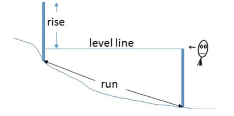
Measuring the rise from the downhill stake to the uphill stake can be accurately done using a clinometer or Abney level by the contest official. In the contest, however, students must estimate slope. The percent slope is estimated to the nearest half integer, from top of stake to top of stake, and students should record that number on their scorecard for later use. Round up to the nearest integer before using table 4 to find the slope class name.
| Slope % | Slope Class |
|---|---|
| < 2 | Nearly Level |
| 2.1 to 7 | Gently Sloping |
| 7.1 to 15 | Sloping |
| 15.1 to 25 | Moderately Steep |
| > 26 | Steep |
Procedure:
Using any flat object such as a clipboard, rolled scorecard, pencil, or top of your hand as a pointer, stand next to the downhill stake and hold the object horizontal in front of you at eye level or on top of the stake. Project a “level line” toward the uphill stake. Walk to the uphill stake and measure the distance from where the “level line” landed up to your eye level or the top of the stake (whichever you used at the downhill stake). Your scorecard is 10 inches tall and can be used as a measuring device.
Examples:
- If you held your arm straight out and the “level line” lands about 2.5 feet below the top of the uphill stake, the rise is 2.5 feet, and the run is 100 feet, and the slope is 2.5/100 x 100 = 2.5%. The slope class from table 4 would be “gently sloping.”
- If your “level line” lands on the ground between the stakes, you should aim using eye level height and walk halfway between the stakes (50 feet) and aim again at the uphill stake. Cutting the distance in half effectively doubles the slope estimate. For example, if you have to walk halfway and aim again and your “level line” lands on the uphill stake about 5 feet below your eye level, the rise is 5 feet, and the run is 50 feet, so the slope is 5/50 x 100 = 10%. The slope class from table 4 would be “sloping.” If it is very steep ground, you may have to walk to within 25 feet of the uphill stake. Your slope effectively quadruples. For example, if your clinometer “level line” then lands on the uphill stake about 4 feet below your eye level, the rise is 4 feet, and the run is 25 feet, and the slope is 4/25 x 100 = 16%. The slope class from table 4 would be “moderately steep.”
Erosion
Erosion is the detachment and transport of soil particles by wind or water. Erosion causes the loss of millions of tons of valuable topsoil (soil formed at the surface and darkened by organic matter and humus) from Virginia soils each year. Most erosion in Virginia is caused by raindrop splash and running water on bare soil. Cleared fields may also be subject to wind erosion.
Soil scientists estimate past erosion by estimating topsoil loss. In order to estimate how much erosion has occurred in a soil judging contest, evaluate the original surface thickness (given information located on the site card at each pit) and the current surface thickness (measured in the soil pit by students) (fig. 3).
Example calculation of erosion class:
(Current surface thickness (measured) / Original surface thickness (given)) x 100 = percent remaining. 100 percent - percent remaining = percent lost. Round negative percent lost values up to 0 percent lost (fig. 11). Negative losses occur where erosion deposits extra topsoil on footslopes.
Example 1: (2 inches current surface thickness / 10 inches original surface thickness) x 100 = 20% remaining. 100% – 20% = 80% lost. Erosion class “Severe.”
Example 2: (5 inches current surface thickness / 10 inches original surface thickness) x 100 = 50.0% remaining. 100% – 50% = 50% lost. Erosion class = “Moderate.”
Example 3: (12 inches current surface thickness / 10 inches original surface thickness) x 100 = 120% remaining. 100-120% = -20% lost (rounded up to 0%). Erosion class = “None to Slight.”
Erosion Classes:
None to Slight: 25% or less of the original surface layer eroded for the soil to be placed in this class. If there is a plow layer, it consists mostly of the original surface horizon material.
Moderate: Moderately eroded soils have lost 25-75% of the original surface layer. If there is a plow layer, it consists mainly of the original surface horizon plus some of the subsoil material. The base of the plow layer rests on or in the subsoil.
Severe: More than 75% of the original topsoil has been lost. If there is a plow layer, it consists mostly of the subsoil material. It has color and texture similar to those of the subsoil.

Landscape Analysis
The landform a soil resides on can influence its properties and its potential use. The landscape is made up of all features that can be seen from a vantage point. Landscapes are made up of many landforms. These landforms influence the type of soil there, how the soil is used, and best management practices. Detailed landscape and geologic analyses are beyond the scope of this program; however, it is important to have a basic understanding of soil-landscape relations to study soil at any level.
Upland Landscapes
The upland landscape (fig. 12) is used to describe all landforms that are not on current or former flooding deposits. To illustrate the relationship between upland ridges, side slopes, and footslopes, sit in a chair and extend your foot, flat on the floor, as far as you can. The portion above your knee is the upland ridge, from your knee to your ankle is the side slope, and your foot is the footslope.

Upland Ridge/Summit: Upland ridge/summits are landforms that form the uppermost part of the local landscape hillslope. They may be somewhat rolling, but are flatter or higher than surrounding side slopes. Soils on upland ridge/summits are usually developed from the dominant underlying geological material (bedrock or Coastal Plain sediments).
Side Slopes: Side slopes are sloping ground between the upland summit and lower, flatter footslopes. Side slopes usually are the steepest sloping part of the local landscape hillslope. Soils on the side slopes are usually developed from the dominant underlying geological material (bedrock or deep Coastal Plain sediment). However, side slopes may also contain gravity moved materials (colluvium), particularly in their lower portions.
Footslopes: Footslopes are slopes at the base of the side slopes that are more gently sloping than steeper side slopes uphill. Soils on the foot slopes are primarily developed in materials carried downhill by gravity (colluvium) from upland ridge summits and side slopes.
Alluvial Landscapes
Alluvial landscapes is the general term used for landforms (flood plains, terraces, and drainageways) formed from alluvium (sediment deposited by flowing water) (fig. 13). The resulting soil is usually sandier and more water sorted, has more gravel, or the gravel is more rounded than the surrounding soils. Floodplains and terraces are parallel to local streams or rivers and tend to occupy the lowest positions of the local area and are usually that flattest area in the immediate setting. Stream terraces, if they exist, are adjacent to and higher than floodplains. Not all floodplains have terraces. Drainageways (ephemeral water channels) form from geologic erosion. Drainageways run perpendicular to floodplains and terraces and they are steeper and higher, sloping down toward the floodplains.
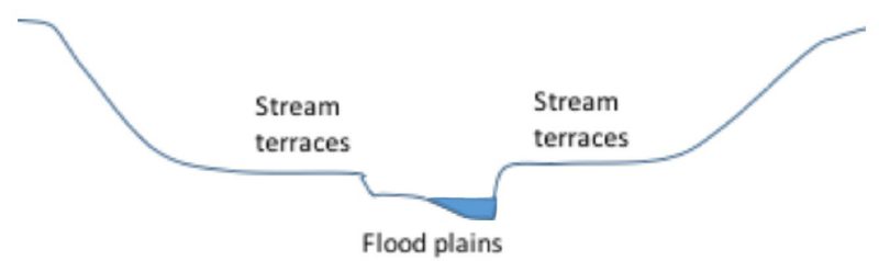
Flood Plains: Flood plains (bottomlands) are the lowest landscapes immediately along streams. On the flood plain, new material is deposited so frequently that the soils are relatively young and not well developed. Many flood plain soils are so young that no subsoil horizon has developed. Flood plains may contain rounded pebbles, and they seldom have any buildings.
Stream Terraces: Once a stream has cut deeper into the landscape, which creates a new flood plain, it leaves an old flood plain above the new flood level. Since the old flood plain is no longer covered by water and sediment, soil formation can occur in that same material for a long time without being buried. These former flood plains that are now above the flood level are called stream terraces and can be found at considerable distances from modern streams.
Drainageways: Before runoff reaches a perennial stream, it collects in small natural drains in higher landscapes called waterways or drainageways (fig. 14). These drainageways slope up from the flood plains and erode into the sloping hillslopes, carrying water only shortly after heavy rains (ephemeral streams). The upper part of the soil in a drainageway is made up of local sediments washed from nearby uplands or side slopes.

Part III: Inferred Soil Characteristics
Inferred soil properties are those that cannot be easily measured. Inferred soil characteristics can also be a combination of or interaction of slope, texture, structure, vegetative cover, and time.
Infiltration Rate
The soil infiltration rate is that rate at which rainfall enters the soil surface rather than flowing across it. This rate is mostly affected by surface layer texture and structure (table 5). In a soil judging contest, students determine the surface layer texture from a sample placed in a container next to the soil pit. Students determine the topsoil structure in the soil pit by using soil material that matches what is in the container. For example, if the students determine that the surface texture is sandy loam, and the soil structure is blocky, the infiltration rate would be “rapid.” If the soil structure had been platy, the infiltration rate would be “medium.”
| Surface Texture | Soil Structure | Infiltration Rate |
|---|---|---|
| Sand, Loamy Sand | Any | Rapid |
| Sand, Loamy Sand | Granular or Blocky | Rapid |
| Sandy Loam | Massive or Platy | Medium |
| Silt Loam, Loam, Silt | Granular or Blocky | Medium |
| Silt Loam, Loam, Silt | Massive or Platy | Slow |
| Silty Clay Loam, Clay Loam, Sandy Clay Loam | Granular | Medium |
| Silty Clay Loam, Clay Loam, Sandy Clay Loam | Blocky, Massive or Platy | Slow |
| Silty Clay, Sandy Clay, Clay | Any | Slow |
Surface Runoff
Surface runoff is the relative rate that water is removed by flowing over the soil surface rather than being removed via infiltration (see above). Surface runoff is affected by slope, slope length, surface texture, vegetative cover, infiltration rate, and the intensity and duration of rainfall. Only slope and infiltration rate are used to estimate surface runoff (table 6).
For the purpose of the contest we will evaluate runoff as “runoff potential from bare soil,” so that vegetative cover extent will not have to be considered. For example, if the percent slope is 2% and the infiltration rate is “medium,” the surface runoff would be “slow” according to table 6.
In reality, however, vegetation on the soil surface greatly decreases runoff. For example, a stable forest with leaf litter has a much slower runoff than a site of pasture grass; grass has slower runoff than bare ground. However, once a soil becomes saturated or the rate of rainfall exceeds the infiltration rate, regardless of texture, slope, or vegetative cover, the surface runoff rate increases.
| Slope % | Rapid Infiltration | Medium Infiltration | Slow Infiltration |
|---|---|---|---|
| <1 | Very Slow | Very Slow | Very Slow |
| 1.1 to 2 | Very Slow | Slow | Slow |
| 2.1 to 7 | Slow | Medium | Rapid |
| 7.1 to 15 | Medium | Rapid | Rapid |
| ≥ 16 | Rapid | Rapid | Rapid |
Rapid - Water is removed from the surface at a rapid rate. A large amount of rainfall is lost and only a small portion moves into the soil increasing the erosion hazard. This is a result of compaction, clayey textures, poor surface structure, and/or slopes greater than 3% (except when the soils are rapidly permeable).
Medium - Water drains away readily, but is slow enough that a large amount of the water enters the soil. This condition causes little erosion hazard and is considered a normal amount of runoff.
Slow - Water flows away so slowly that free water covers the soil for moderate periods. This increases the moisture supply but may interfere with farming operation.
Very Slow - Water is removed so slowly or stands so long that the soil remains wet for long periods. Most of the water either passes through the soil or evaporates. Generally, this condition occurs on level to slightly concave slopes. However, deep sandy soils with rapidly permeable subsoils on slopes also have very slow runoff. This is because the infiltration is so high that rainfall produces little or no runoff.
Permeability
Permeability is the rate that water moves or percolates downward through the soil following infiltration. Soil texture has a major effect on subsoil permeability (fig. 15), but other properties such as structure, bulk density, pore size and quantity, root channels, and animal or insect burrows affect permeability as well (Easton and Bock 2016). In this soil judging contest, permeability will be determined based on texture and structure (table 7) of the subsoil horizon that matches the sample in the subsoil texture box.

| Subsoil Texture | Structure | Permeability |
|---|---|---|
| Sand, Loamy Sand | Any | Rapid |
| Sandy Loam1, Loam, Silt Loam, | Any | Moderately Rapid |
| Sandy Clay Loam, Clay Loam, Silty Clay Loam | Any | Moderate |
| Clay, Sandy Clay, Silty Clay | Blocky or Prismatic | Moderate |
| Clay, Sandy Clay, Silty Clay** | Platy or Massive | Slow2 |
1 Sandy loams with significant amounts of gravel (15% or more) have rapid permeability.
2 Hardpans, claypans, and fragipans always produce slow permeability regardless of texture.
For example, if the subsoil texture sample is clay loam, and the structure of that horizon observed in the pit is blocky, the permeability would be “moderate.” Hardpans, claypans, and fragipans limit percolation rates, regardless of their texture. Hardpans are dense and platy horizons at the base of a plow layer caused by severe compaction of plowing a wet soil with heavy machinery. Claypans and fragipans (fig. 16) are naturally occurring subsoils.

Natural Soil Drainage Classes
Natural soil drainage (drainage class) is the result of the interaction of soil texture and depth to gray mottles (table 8) (Soil Survey Staff 2017). The interpretation of drainage class depends on the intended use. Excessively drained soils do not hold enough water for optimum plant growth and do not have wetness mottles or evidence of a water table in the profile. Poorly drained soils (wet near the surface for long periods) are opposite in that they are so wet that crops can only grow if the soils are artificially drained. Moderately well drained soils may be wet late in the spring but are not wet enough to warrant drainage ditches. Well drained soils do not have water tables at depths shallow enough to hinder agricultural use. Depth to seasonal high water table (or wetness) is indicated by depth to standing water or by gray mottles or colors (fig. 8) measured in the pit, whichever is shallowest. Depth to seasonal high water table and subsoil textures are evaluated in determining the following drainage classes. For example, if the subsoil texture is loamy sand and the depth to gray mottles is 20 inches, the drainage class is “moderately well.”
| Drainage Class | Subsoil Texture | Depth to Water or Gray Mottles (inches) |
|---|---|---|
| Excessively | Sand or loamy sand | >36 |
| Well | Any textures except sand and loamy sand | >36 |
| Moderately Well | Any textures | 18 to 36 |
| Somewhat Poor | Any textures | 10 to 18 |
| Poorly | Any textures | 0 to 10 |
Excessively Drained - Seasonal high water table is not within the rooting zone long enough during the growing season to adversely affect yields, and the texture is sand or loamy sand that drains rapidly.
Well Drained - Seasonal high water table is not within the rooting zone long enough during the growing season to adversely affect yields. The B horizon is usually uniform in color.
Moderately Well Drained - Seasonal high water table is within the rooting zone for a sufficiently long period of time to adversely affect some crops unless the soil is artificially drained.
Somewhat Poorly Drained - Seasonal high water table is near the surface for periods long enough to affect yields unless an artificial drainage system is installed. The horizon immediately below the A horizon is not dominantly gray.
Poorly Drained - Seasonal high water table is at or near the surface during a large part of the year. The A horizons are dark gray to black, and subsurface horizons immediately below the A horizon are dominantly gray. Very poorly drained soils are ponded most of the year or tidally flooded.
Excess water is a problem in moderately well, somewhat poorly, and poorly drained soils. Another equally important problem is retaining sufficient water within the rooting depth to supply plant needs. Water that is held briefly by the soil for plant growth between wilting point and field capacity is called “plant available water.” Excessively drained soils usually cannot hold adequate available water for plant growth. Available water for plants in all other drainage classes varies depending on soil texture and structure.
Part IV: Agricultural Management
Land Capability Classification:
The land capability classification system groups soils with similar potential for cultivated crops, pasture, range, forestry, and wildlife (Warren 2016; Edmonds et al. 1998). Classes I through IV are capable of producing cultivated crops. Soils in classes V, VI, and VII are not suited to cultivated crops but are suitable for pasture and forestry. Soils in class VIII are suitable only for wildlife and recreation.
Complete definitions of the eight land capability classes are given below. Contestants use table 9 as a key to identify the class, and use table 10 to check the class placement made. For all classes: Flooding frequency and ponding duration (occasional or frequent) are given for each site in the land-judging contest. If no flooding frequency or ponding duration is given, assume no flooding occurs.
| Criteria | Class |
|---|---|
Unacceptable Limitations: Sand or loamy sand surface texture |
I |
Unacceptable Limitations: Sand or loamy sand surface texture |
II |
Unacceptable Limitations: Stony surface texture |
III |
Unacceptable Limitations: Stony surface texture |
IV |
Unacceptable Limitations: Rock or a fragipan is less than 20 inches deep |
V |
Requirements (Must have one of the following): Rock or fragipan is < 20 inches deep |
VI |
| Meet one or more criteria for class VI, but slope and erosion cannot be modified enough to allow any pasture or cropland use. The site may allow grazing native plants or harvesting specialty fruit crops such as blueberries. | VII |
| All other soils. Nearly barren areas, only suited to native plants. | VIII |
Class I Land: Class I land has few or no conditions that limit its use for most common agriculture crops; it can be safely cultivated without special conservation treatment. Class I land soils may be used safely for cultivated crops, pasture, range, forestry, and wildlife. Because they are nearly level, the water erosion hazard is low. Wind erosion may be high if textures are sandy and the soil is left bare. They are deep, generally well drained, and easily tilled. They hold water well and are either fairly well supplied with plant nutrients or highly responsive to fertilizer. Class I land does not have a wetness problem or other unfavorable soil characteristics in the root zone. These soils are not subject to flooding.
Class II Land: Class II land has some natural conditions that require some conservation practices when it is cultivated or that limit the kinds of plants it can produce. Class II soils require more careful management than do those of class I land, including conservation practices, to prevent deterioration or to improve air and water relations when the soils are cultivated. The limitations are slight, however, and the practices are easy to apply.
Class III Land: Class III Land has one or more moderate limitations on its use. These soils are more restricted in the crops that can be produced than are those in classes I and II. When cultivated, conservation practices are more difficult to implement, and/or maintenance is usually required. Class III soils have limitations, as they restrict the amount of clean cultivation; time of planting, tillage or harvesting operations; choice or yield of crops; or a combination of these. The limitations may be natural ones, such as steep slopes or wetness problems, or the limitations may be the result of erosion brought on by the way land has been used.
Class IV Land: Class IV land is suitable for only occasional or limited cultivation. It has one or more severe limitations that restrict its use and the kinds of plants that can grow. Class IV land requires very careful management when cultivated. Conservation practices are more difficult to apply and maintain than on soils in classes I, II and III. Class IV land includes soils in areas where flooding may preclude planting or harvesting crops during unfavorable years. Many sloping, class IV soils in humid areas are suited to occasional, but not regular, cultivation because of the severe erosion hazard. Some of the poorly drained, nearly level soils are not subject to erosion but are poorly suited to some crops because of wetness problems or low productivity for cultivated crops. Some hilly soils in class IV are well suited to one or more special crops, such as fruits or ornamental trees and shrubs.
Class V Land: Class V land is level, but has some conditions that limit its use to pasture or range, forestry, recreation, watershed protections, or wildlife habitat. The soils in class V land have limitations other than erosion that restrict the kinds of plants that can be grown and/or that prevent tillage of cultivated crops. Examples of limitations are: a) stony surface texture; b) subject to frequent flooding; and c) ponded areas where drainage is not feasible.
Class VI Land: Class VI land has soils with very severe limitations that make it unsuitable for cultivations. Class VI soils are best restricted to pasture, range, forestry, recreation, watershed protection, or wildlife habitat. It may be well or poorly suited to forestry, depending on the characteristics of the soil. For these soils, it is practical to apply range or pasture improvement such as seeding, liming, fertilization, or water control by means of contour furrows, drainage ditches, diversions, or water spreaders. Some soils in class VI are well adapted to long-term meadows and sodded orchards that do not require cultivation or to special crops such as blueberries that require soil conditions unlike those demanded by most cultivated crops.
Class VII Land: Class VII land has soils with very severe limitations that make it unsuited for cultivation. Class VII is used for range, forestry, recreation, watershed protections, or wildlife habitat. Even these uses in class VII soils require careful management. Soils in the class VII land have restrictions more severe than those in class VI because of one or more limitations that cannot be modified. These conditions make the land unsuited for common cultivated crops, although some special crops with precision management practices can be grown. Physical conditions of the soils make it impractical to apply pasture or range improvements. Soils in this class range from well to poorly suited for forestry.
Class VIII Land: Class VIII land has soils with severe limitations that prevent its use for commercial production of anything other than native plants. Soils and landforms in class VIII cannot be expected to return significant on-site benefits from management for crops, grasses, or trees. Benefits from wildlife use, watershed protection, or recreation may be possible. Bedrock outcrops, sand beaches, river wash, mine tailings, and other nearly barren areas are included in class VIII.
| Soil Factor | Criteria | Best Class |
|---|---|---|
| Surface Texture | Sand, Loamy Sand | III |
| Surface Texture | All other textures | I |
| Surface Texture (stoniness) | Stony | V |
| Surface Texture (stoniness) | Not stony | I |
| Depth to Bedrock or Fragipan | < 20 inches (shallow) | VI |
| Depth to Bedrock or Fragipan | > 20 inches (deep or moderately deep) | I |
| Rock outcrops | Rock outcrops 10 feet or less apart | VI |
| Permeability | Rapid | III |
| Permeability | Moderate, Moderately Rapid | I |
| Permeability | Slow | II |
| Slope | Nearly Level (0 to 2%) | I |
| Slope | Gently Sloping (2.1 to 7%) | II |
| Slope | Sloping (7.1 to 15%) | III |
| Slope | Moderately Steep (15.1 to 25%) | IV |
| Slope | Steep (>26%) | VI |
| Erosion | None to Slight | I |
| Erosion | Moderate | II |
| Erosion | Severe | VI |
| Runoff | Rapid | III |
| Runoff | Medium or Slow | I |
| Runoff | Very Slow | II |
| Wetness | Ponded (cannot be drained) | V |
| Wetness | Water Table at 0 to 18 inches | III |
| Wetness | Water Table > 18 inches | I |
| Flooding | None | I |
| Flooding | Occasional | II |
| Flooding | Frequent | V |
Soil Amendments:
A soil amendment is any substance added to the soil that alters soil properties (Haering and Evanylo 2015). Examples are lime and fertilizers. The pH, P, and K levels needed are based on soil tests of the surface layer for plant available nutrients (Maguire and Heckendorn 2010). It is assumed that all of the plant’s nutritional needs can be supplied by fertilizer and lime applications to the surface layer because most of the root system is in that layer.
Soil pH - Lime is used to correct excess soil acidity and to supply calcium (Ca) or magnesium (Mg) as plant nutrients. Soil pH also affects the availability of most nutrients to plants and their mobility in soil water (fig. 17). For example, Phosphorus becomes less available at pH less than 6.5 and micronutrients such as boron, copper, and zinc become less available at pH 7.0 or above. Calcitic limestone (CaCO3) and dolomitic limestone (MgCO3) are the most common agricultural liming products. Lime should be added for most agronomic crops if the pH is less than 6.0. Soils with a pH of 8.0 are alkaline and elemental sulfur (S) can be used to lower the pH. Ammonium (NH4) containing nitrogen fertilizers like ammonium nitrate or ammonium sulfate can also be used to lower soil pH.

Nitrogen (N) - Nitrogen should be added to every crop except legumes, which associate with microbes that fix atmospheric nitrogen. Nitrogen is a major component of chlorophyll and amino acids in plants and microbes. As part of the information given for each site for the soil judging contest you will be told the crop to be grown.
Phosphorus (P) - Phosphorus is needed on crops except when the soil test is very high (starter P applied as a band may be beneficial when the soil test is high). Phosphorus is used in photosynthesis, respiration, energy storage, and cell growth in plants. The phosphorus content of a fertilizer is expressed as percent phosphate (P2O5).
Potassium (K) - Potassium is needed on crops except when the soil test is very high. Potassium regulates stomate opening and closing and production of ATP in plants. The potassium content of a fertilizer is expressed as percent potassium oxide (K2O) and is often called “potash.”
None Needed - The soil has an adequate amount of lime and fertilizer to produce the highest yield that the soil is capable of producing (this assumes that rainfall is not a limiting factor).
Land Management Systems
Land management systems involve both crop rotation and tillage systems.
It is assumed that the land will be used as intensively, sustainably, and as economically as possible. The tillage system involves no long-term soil modifications.
Continuous Row Crops: For Class I Land
Sod or Legume Crop Every 4th Year: For class II soils.
Sod or Legume Crop Every 3rd Year: For class III soils that are not sandy.
Sod or Legume Crop Every 2nd Year: For sandy class III soils and all class IV soils.
Surface Residue Management and/or Minimum Tillage: This is a management system using an off-set disk or similar implement to prepare a seedbed with as few passes as possible over the field. Surface residue management involves leaving as much crop residue exposed or only slightly mixed into the surface layer thus enhancing infiltration and reducing erosion. Minimum tillage should leave the soil surface quite rough, also enhancing infiltration and reducing erosion. Some types of minimum tillage and/ or residue management system should be used in all row crops (corn, soybean, wheat, etc.) production.
Establish Recommended Grasses and Legumes—For class V and VI soils.
Establish recommended grasses and legumes — This practice should be selected on class V and VI Soils.
Control grazing and proper pasture management – The goal of this practice is to utilize rotational grazing and proper stocking techniques that will maintain or improve the pastures. This practice should be used on class V and VI Soils.
Plant Recommended Trees and Harvest Trees selectively — Choose when indicated on given information and on all Class VII Soils. This practice is used to manage selective trees by removing undesirable tree species and harvest desirable species.
Use Only for Wildlife or Recreation — For Class VIII Soils. This means that this area cannot be used for grazing, crop production, or urban uses.
Note: No-till planting is almost always a good replacement for any other tillage practice. No-till practices offer good erosion protection and increases water content in the soil. No-till was not included as an option emphasize the need to manage by capability class.
Mechanical Practices
Mechanical practices serve to reduce a soil limitation within a given land capability class. This way, the soil can be used more intensively and sustainably without degradation.
No Treatment Needed: This would be checked on (a) class I land where brush and trees are not a problem, (b) class II land where erosion and drainage are not problems, (c) on sandy soils without an erosion problem
Farm on Contour, or Strip Crop: Framing on contour or strip cropping is used on soils to reduce erosion hazard to an acceptable level for a given management system. Select for class II, III, and IV soils.
Control Brush or Trees: Select this practice for soils that are capable of growing crops or improved pasture where brush or trees are too big to be removed by normal tillage operations (greater than 2 inches in diameter and/or 5 feet in height).
Control Gullies: Control existing gullies by establishing grassed waterways and by filling and grading. This conservation practice should be recommended any time that active gullies are within the field area. Gullies are defined as being at least six inches deep and twelve or more inches wide.
Part V: Soil and Land Use Interpretations
Only a small percentage of our population is actually involved in food, feed, and fiber production. The tremendous productivity of the agricultural sector allows most of us to work in non-agricultural areas. It is critically important that we all understand the need to conserve our soils for agricultural use, but for many of us the impact of non-agricultural land use will directly affect us. For example, in purchasing a house, many critical soil properties should be considered. This section provides an opportunity to learn how to evaluate soil for uses other than food and fiber production.
Scorecard Interpretations
When using soil for non-agricultural purposes, the emphasis shifts from surface to subsurface soil properties. In addition, the impact of infrequent catastrophic events, such as flooding, are much more important than in most agricultural uses.
In this section, important soil properties are evaluated and identified; then the limitation of that soil property for a specific use is determined. On the soil judging scorecard, it must be realized that scorecard location for a soil property evaluation has no
relationship with scorecard location for use limitations. For example, rapid is the third choice down for permeability but has slight limitations (first choice) for homesite foundations (no basement) (table 11).
Use limitations categories for each soil feature are those used by the National Cooperative Soil Survey (Edmonds et al. 1998). They are defined as follows:
Slight Limitations: Those soils or locations that have properties favorable for the planned use and present few or no problems.
Moderate Limitations: Those soils or locations that have properties only moderately favorable for the planned use. Limitations can be overcome or modified with special planning, design, or maintenance. Special treatment of the site for the desired use may be necessary.
Severe Limitations: Those soils that have one or more properties unfavorable for the planned use. Limitations are difficult and costly to modify or overcome for the use desired.
After limitations on each use, for each soil feature, have been determined, a final evaluation for each use is completed. This determines the overall limitation on the use of the site. The final limitation is based on the most restrictive soil-site property. For example, if a soil is rated slight for homesite foundations (no basement) (table 11) for all features except it is rated severe for frequent flooding, it receives a final evaluation of “severe” because the most limiting factor will control the use. Everything else may be suitable for a homesite, but if the site floods frequently, it is not a desirable homesite.
| Soil Property | Slight | Moderate | Severe |
|---|---|---|---|
| Subsoil Texture | All others | Sands, low shrink-swell clays | High shrink-swell clays |
| Permeability | Rapid, Moderately Rapid, Moderate | --- | Slow |
| Depth to Bedrock | > 3 Feet | 2 to 3 feet | < 2 Feet |
| Slope | 0 to 7% | 8 to 15% | > 16% |
| Water Table Depth | > 3 Feet | 2 to 3 feet | <2 feet |
| Flooding | None | Occasional, Frequent |
Soil Properties to be Evaluated
Most of the properties evaluated in this section are similar to those evaluated in Parts 1, 2, and 3. Limits for classes may be somewhat different in this section since we are more concerned about internal water flow and soil properties at greater depths. Differences between this section and other sections are discussed below.
Texture: Four general textural classes are used for soil interpretations.
- Sands and loamy sands are combined into the general class of sands.
- Sandy loams, silts loams, loams, sandy clay loams, silty clay loams, and clay loams are combined into the general class of loams and clay loams.
- Sandy clays, silty clays, and clays are grouped into the clay class.
- Clays are separated into two types, those with low shrink-swell and those with high shrink-swell. Shrink-Swell is the relative change in volume on wetting and drying. Shrink-swell is estimated indirectly in the field according to the plasticity of the soil. Where high shrink-swell soils occur, they limit many land uses.
- Clays with high shrink-swell are “tight” (stiff when texturing) and hard to work, and have shiny pressure faces on peds due to repeated volume change. Shrink-swell clays can form very thin ribbons during texturing. High shrink-swell clays are associated with sticky, cracking claypan subsoils in some Piedmont soils or brown limestone soils in the Valley & Ridge.
Low Shrink-Swell Clays: Most clays in Virginia are not high shrink-swell, and do not meet the description of high shrink-swell clays above.
Permeability: The same classes are used, but for this section rates of flow are considered.
Depth to Bedrock: Class limits are based on impact on land use, but limitation breaks for a specific use do not necessarily correspond with class breaks. The importance of depth to bedrock depends on the use.
Slope: Slope breaks are the same as in Part 2, but more than one slope class may have the same limitation for a specific use.
Water Table: The three water classes used to reflect relative impact on use, but class breaks do not correspond to limitation breaks for a specific use.
Flooding: Flooding classes are given on data card and based on frequency of occurrence. Frequent flooding occurs at least one year in five. Occasional flooding occurs less often than one year in five. If no flooding frequency or ponding duration is given on the site card, assume none occurs.
Determination of Use Limitation
Foundation (No Basement)
Soil properties evaluated are depth to bedrock, slope, landscape position, texture of the soil at a depth of two to seven feet and depth to a water table or gray wetness mottles. It is assumed that footings will be placed thirty inches below the surface. Table 11 is used to determine the degree of limitation for foundations (no basement) based on these soil properties.
High shrink-swell clays could cause the foundation to crack. Slow permeability makes it likely that wetness will be a problem around the foundation.
Removing bedrock is expensive, but if part of the foundation is on hard bedrock and part on clay, the foundation may not be stable. Special designs can reduce this problem but are expensive.
On steep slopes, it becomes more difficult to prepare suitable footings. House sites on steeper slopes may require special designs and are usually more costly. Cut and fill associated with site development
on steep slopes is also expensive. Water in the subsoil reduces the soil- bearing capacity, making it susceptible to slippage and foundation cracks. High humidity increases the chance for wetness problems in the house. House foundations should not be built on sites subject to flooding.
Septic Tank Absorption Fields
Disposal of human waste is a critical role that the soil must handle. Wastewater entering a drain field (fig. 18) must then pass through the oxygenated soil at a moderate rate. This will allow microbes to decompose the remaining organic matter, oxygen to kill harmful anaerobic microbes, and clays to absorb excess nutrients. The soil in a drainfield must be able to filter wastewater equivalent to 200 inches of rainfall a year. Therefore, a good drainfield soil must be moderately permeable and deep to water and bedrock (table 12). A certain minimum thickness of soil, depending largely on permeability, is needed for effectively filtering wastewater. A minimum thickness of 18 inches of suitable soil is required between the drainfield trench bottom and either bedrock or water table.

| Soil Property | Slight | Moderate | Severe |
|---|---|---|---|
| Subsoil Texture | All others | Low Shrink-Swell Clays | Sands and High- Shrink Clays |
| Permeability | Moderately Rapid | Moderate | Rapid and Slow |
| Depth to Bedrock | >5 Feet | 3 to 5 feet | < 3 Feet |
| Slope | 0 to 7% | 8 to 15% | > 16% |
| Water Table Depth | >6 Feet | 4 to 6 feet | < 4 feet |
| Flooding | None | ---- | Occasional, Frequent |
Soil texture that is too sandy allows wastewater to enter the groundwater too rapidly. Clays with high shrink-swell potential swell shut when wet and severely limit permeability. Rapid or slow permeability makes it likely that water will percolate either too rapidly or too slowly for microbial treatment and cleanup of contaminants. Bedrock near the land surface often has open cracks that wastewater can enter and flow directly to the groundwater, especially in areas of limestone or dolomite and cave systems. Slope that is steep allows wastewater to rise to the soil surface or requires many trenches, raising the cost of installation. Water in the subsoil may intercept wastewater and carry it to groundwater or surface water, and the lack of oxygen in wet soils limits the microbial treatment and cleanup of contaminants. Drainfields should not be built on sites subject to flooding because in flood events the wastewater directly enters the stream system.
Shrubs and Trees
Most of the soil around a newly built home has been highly disturbed during construction. Often the topsoil is put back on top of subsoil. Shrubs and trees include those normally used as ornamental plantings around the homesites. Table 13 is used to determine the degree of limitation for trees and shrubs.
| Soil Property | Slight | Moderate | Severe |
|---|---|---|---|
| Subsoil Texture | All others | Sands, Clays | --- |
| Permeability | Moderate, Moderately Rapid | Rapid | Slow |
| Depth to Bedrock | > 3 Feet | 1.5 to 3 feet | <1.5 feet |
| Slope | 0 to 7% | 8 to 25% | > 26% |
| Water Table Depth | > 3 Feet | 1.5 to 3 feet | <1.5 feet |
| Flooding | None, Occasional | Frequent | --- |
Clays may seal and cause “drowning of tree roots.” Sands will hold water inadequately. Slowly permeable soils will slowly cause “drowning of tree roots” as soils lose oxygen. Rapidly permeable soils will not keep water in the root zone. Woody plants need adequate depth to bedrock or water tables for roots to uptake water and nutrients. Excessive slopes increase runoff and erosion and reduce water available for growth. Frequent flooding can damage shrubs and cause “drowning of tree roots” as soils lose oxygen.
Soils for Road-fill
Soil properties important for road-fill or fill of any kind relate to soil texture, rock content (not estimated in this contest), and thickness of suitable material (table 14). The table below rates the suitability of a source area for materials, not for location of the road.
| Soil Property | Slight | Moderate | Severe |
|---|---|---|---|
| Subsoil Texture | All others | Sands | Clays |
| Permeability | Moderate, Moderately Rapid | Rapid | Slow |
| Depth to Bedrck | >5 feet | 3 to 5 Feet | < 3 Feet |
| Slope | 0 to 15% | 16 to 25% | > 26% |
| Water Table Depth | >5 Feet | 3 to 5 Feet | < 3 Feet |
| Flooding | None, Occasional | Frequent | ---- |
Soil materials that are too high in clay or sand are less desirable than soil materials with a good mixture of sand-, silt-, and clay- sized particles. Rock content is favorable for road-fill because it withstands heavier weights and has fewer ruts. A sufficient depth of suitable material above bedrock or a water table is needed for economic operation. What is left must be capable of growing plants with appropriate additions of lime and fertilizer. When removing soil to construct a road the disturbed area must be protected from erosion while soil is being removed and while vegetation is being reestablished. Installing a silt fence should always be recommended when land is disturbed for road-fill.
Waste Lagoons
Waste lagoons for holding animal manure and other waste require a very slowly permeable soil or one that can be made impermeable. Most lagoons are a combination of an excavation and a berm. In any case, it is most economical to use excavated soil material for a lining or to obtain nearby soil material for such uses. The floor and side walls of a lagoon must have very slow permeability rates such that wastewater will not leak into local groundwater or surface water. Table 15 lists those soil properties that must be evaluated for this kind of use.
| Soil Property | Slight | Moderate | Severe |
|---|---|---|---|
| Subsoil Texture | All others | Loams, clay loams, high shrink-swell clays | Sands |
| Permeability | Slow | Moderate, Moderately Rapid | Rapid |
| Depth to Bedrock | > 6 Feet | 3 to 6 feet | < 3 Feet |
| Slope | 0 to 2% | 3 to 7% | > 8% |
| Water Table Depth | > 6 Feet | 3 to 6 feet | < 3 Feet |
| Flooding | None | --- | Occasional, Frequent |
The permeability of the side walls and bottom of a lagoon must be slow or the soil must be modified to make it impermeable. Rapidly permeable material is unsuitable because of leakage. Moderate and moderately rapid soils require more expensive modifications such as severe mechanical compaction. In some cases, a costly plastic or rubber liner is needed. Often, local clayey soil material can be used to line ponds and lagoons. High shrink-swell clays may crack after the lagoon if emptied and may leak when the lagoon is refilled. Shallow depth to bedrock or water table reduces the depth of a lagoon pond. Exposed bedrock must be sealed, and animal waste cannot be allowed to contact the water table, where it can enter the groundwater or stream system. Steep slopes make construction difficult and costly. Flooding could lead to a washout of lagoon contents unless the berm is above flood level.
Part VI: Setting up and Holding a Soil Judging Contest
Selection of Site
The following information is derived from Land Judging in Oklahoma (Warren 2016) and Land Judging and Soil Evaluation (Edmonds et al. 1998).
A site should have only one landscape and slope gradient. The area to be evaluated should be marked with flagging or stakes. Depending on the land form complexity, a site may be small or large in area. When a field with complex slopes is being evaluated, the pit and slope stakes should be located in the least variable part. A team consists of three or four contestants with the three high scores tabulated as the official team score. A club may enter a junior and senior team in the event. Students that have competed in the National Soils Contest are not eligible for state-level competition.
Slope: slope stakes should be located 100 feet apart (fig. 19). The slope should be measured, and the stakes moved so that they represent the area where the pit is and are not between or on one end of the slope class range.

Soil Profile: A pit should be 3-5 feet deep and 15 feet long with a gradual slope into the pit. The pit should be of sufficient width to allow at least six people to judge simultaneously. Auger holes are not an acceptable way to expose a soil profile. A recent road cut can be used. The contestant can evaluate only what can be observed. So, if soil properties below the depth of the pit to 7 feet are important for interpretations, they must be listed on the information card (appendix A - CSES-202P-A). The width and depth of the soil pit must meet with all pertinent local and state trench safety standards.
The control area evaluated by the judges should be marked for the entire length of the profile. This area should be used for measurements and contestants should not dig in this area. This no-pick zone should be marked off with flagging by the judges. The soil profile exposed in the pit wall is assumed to be representative of the soil in the area being evaluated.
Topsoil and subsoil layers must be put into boxes so that everyone has equal access to the surface soil and subsoil. The box samples may be used for texture, but the structure is determined in the soil pit in the horizons that matches what is in the texture box. Depth to gray mottles, water table, or bedrock is measured in the pit from the top of the surface mineral horizon. Do not include the O horizon if one occurs.
An information card at each pit should include:
- Original soil thickness (can be estimated).
- pH of surface soil (can be estimated).
- Depth to bedrock and water between the pit and seven feet.
- Phosphorus and Potassium soil test levels (can be estimated).
- Crop to be planted (If a legume is to be grown- no nitrogen is needed).
- Flooding and ponding information (if appropriate).
- Distance between slope stakes.
- A reminder not to dig in the control area.
General Rules
Students will be given 20 to 30 minutes per site to complete their score sheets, additional travel time between sites will provided.
- No talking, comparing, or copying scoresheets.
- Clear Plastic clipboards are recommended.
- No water bottles. Water to moisten soil will be provided at the site.
Contestants can bring the following equipment:
- Pencils.
- Tape measure or ruler.
- Knife or nail to dig.
- Towel or rag.
- Clip board.
- Score cards.
- Four function calculator.
Handouts to students: On the morning of the contest, each contestant should be given a packet containing four scorecards (appendix B - CSES-202P). The scorecards should be printed on cardstock and each pit should be evaluated using a different designated color, of paper. It is recommended that the colored scorecard be posted at each site. There should only be one member of each team at each soil pit.
Student A should start at pit 1, then go to 2, 3 and then 4.Student B should start at pit 2, then go to 3, 4 and then 1. Student C should start at pit 3, then go to 4, 1 and then 2. Student D should start at pit 4, then go to 1, 2 and then 3.
Scoring: Have individuals familiar with the contest procedures verify the answer keys prior to beginning grading and designate a person to as the lead authority for interpreting grading rules. Provide detailed instructions for the graders so that the scoring procedures are completed uniformly. Double check scores before turning them over to the tabulation committee. The total score for the pit should be circled on the front of the scorecard. The tabulation committee should set up a spreadsheet that totals the four pits scores. A formula should be utilized that adds the top three scores for each team together for the team score. The fourth contestants score, low team score, can still qualify for individual awards. The data entry person should put bogus data (scores) into the spreadsheet and hand check the spreadsheet formulas before the official scores are entered.
Results: The contest results should be announced by an official as soon as possible after the contest. The top five to ten individuals should be recognized then the top teams are recognized. The announced results will be final. The return of the scorecards to the contestants is left to the discretion of the contest official.
Tie Breakers: In case of an individual or team tie the high score on pit 1, then pit 2, then pit 3, then pit 4 will be used to break the tie. If the teams are still tied after the first tiebreaker then the forth-individual’s score will be added to the team score to break the tie.
Resource People: In many localities, USDA-NRCS soil scientists, Virginia Tech soils extension specialists or soils faculty are available to assist with site selection and evaluation of soil profiles. Extension agents, SWCD, and USDA-NRCS conservationists should assist with agricultural and urban interpretations.
Additional Resources: It is recommended that a portable toilet should be provided at the contest site, along with water and first aid supplies. Snacks may be provided while the results are tabulated.
Duties of the Pit Monitors
A few minutes before starting the time, announce:
- The pit number and the color of cardstock to use at this location.
- No digging allowed in the restricted area.
- Identify the location of the topsoil box and the subsoil box.
- Identify the location of the water bottle.
- Identify the slope stakes.
- Identify the location of the information given by the judges.
- Remind the students to be courteous and safe when entering the pit.
- Scorecards should be collected by the pit monitor when the horn sounds.
Additional Resources:
DeMarco, L. W. 2014. It’s More Than Just Dirt: Exploring the World of Plants and Soils. Project Book 1. Virginia Cooperative Extension. Publication 380-020. www.pubs.ext.vt.edu/380/380-020/380-020_pdf.pdf
Easton, Z. M., and E. Bock. 2016. Soil and Soil Water Relationships. Virginia Cooperative Extension. Publication BSE-194P. www.pubs.ext.vt.edu/BSE/BSE-194/BSE-194-PDF.pdf
Maguire, R., and S. Heckendorn. 2010. Soil Test Note #1 - Explanation of Soil Tests. Virginia Cooperative Extension. Publication 452-701. www.pubs.ext.vt.edu/452/452-701/452-701_pdf.pdf
Haering, K. C., and G. K. Evanylo. 2015. The Mid-Atlantic Nutrient Management Handbook. Virginia Cooperative Extension. Publication CSES-122P. www.pubs.ext.vt.edu/CSES/CSES-122/CSES-122-pdf.pdf
Easton, Z. M., and E. Bock. 2016. Soil and Soil Water Relationships. Virginia Cooperative Extension. Publication BSE-194P. www.pubs.ext.vt.edu/BSE/BSE-194/BSE-194-PDF.pdf
Edmonds, W. J. Thomas, P. J. Simpson, T. W., and J. C. Baker. 1998. Land Judging and Soil Evaluation. www.vaswcd.org/wp-content/uploads/2011/10/Land-Judging-and-Soil-Evaluation.pdf
Haering, K. C., and G. K. Evanylo. 2015. The Mid-Atlantic Nutrient Management Handbook. Virginia Cooperative Extension. Publication CSES-122P. www.pubs.ext.vt.edu/CSES/CSES-122/CSES-122-pdf.pdf
Maguire, R., and S. Heckendorn. 2010. Soil Test Note #1 - Explanation of Soil Tests
Virginia Cooperative Extension. Publication 452-701. www.pubs.ext.vt.edu/452/452-701/452-701_pdf.pdf
Schoeneberger, P.J., D.A. Wysocki, E.C. Benham, and Soil Survey Staff. 2012. Field Book for Describing and Sampling Soils, Version 3.0. Natural Resources Conservation Service, National Soil Survey Center, Lincoln, NE. https://www.nrcs.usda.gov/wps/portal/nrcs/detail/soils/ref/?cid=nrcs142p2_054184
Soil Science Society of America. 2008. Glossary of Soil Science Terms. Soil Science Society of America. www.soils.org/publications/soils-glossary (Accessed 13 Mar. 2017)
Soil Science Division Staff. 2017. Soil Survey Manual. C. Ditzler, K. Scheffe, and H.C. Monger (eds.). USDA Handbook 18. Government Printing Office, Washington, D.C. Available online at: https://www.nrcs.usda.gov/wps/portal/nrcs/detail/soils/ref/?cid=nrcs142p2_054262
USDA-NRCS. 2017. National Soil Survey Handbook, Title 430-VI. U.S. Department of Agriculture, Natural Resources Conservation Service. http://www.nrcs.usda.gov/wps/portal/nrcs/detail/soils/ref/?cid=nrcs142p2_054242 (accessed 15 March 2017).
Warren, J. 2016. Land Judging in Oklahoma. Oklahoma Cooperative Extension. Publication 4H-HPS-101. www.landjudging.com/2009/land_judging_manual_2009.pdf
Glossary of Terms
Many of the following definitions were taken from the Glossary of Soil Science Terms (Soil Science Society of America 2008).
Alluvium: Sediment deposited by flowing water.
Available Nutrient: The quantity of a nutrient element or compound in the soil that can be readily absorbed and taken up by growing plants.
Available Water: The portion of water in a soil that is available to be absorbed by plant roots (the amount of water held between wilting point and field capacity).
Bedrock: The solid (consolidated) rock layers underlying soils. Cementation ranges from very weak to strong.
Clay: As a soil-separate: individual particles less than 0.002 mm in diameter. As a textual class: a soil that is 40% or more clay, less than 45% sand, and less than 40% silt.
Clayey: Containing large amounts of clay.
Claypan: A layer in the subsoil having a much higher clay content and density than the overlying horizons, from which it is separated by a sharply defined boundary. Claypans are usually hard when dry and plastic and sticky when wet. They usually impede the movement of water and air and limit the growth of plant roots.
Coastal Plain Sediments: Unconsolidated sediment deposited by rivers and oceans.
Colluvium: A deposit of rock fragments and soil material accumulated on footslopes at the base of steep slopes as a result of gravity driven movement. May also be found on lower sideslopes, particularly in the Piedmont and Blue Ridge.
Drainage: The act of creating open ditches or installing drainage tile, so that excess water can be removed by surface or by internal flow.
Erode: To wear away or remove the land surface by wind, water, or other transportation agents.
Erosion: 1) The wearing away of the land surface by running water, wind, ice, and other geological agents, including such processes as gravitational creep. 2) Detachment and movement of soil or rock by water, wind, ice, or gravity.
Fertilizer: An amendment that supplies one or more of the nutrients essential to plant growth.
Field Capacity: The content of water remaining in a soil 2 or 3 days after having been wetted with water and after drainage due to gravity is negligible.
Fragipan: A natural subsurface horizon with high density relative to horizons above. Fragipans are seemingly cemented when dry, but when moist they rupture when squeezed and break in a sudden manner of failure called brittleness in about three-fourths or more of the volume of the horizon. The layer is low in organic matter, mottled, slowly or very slowly permeable to water, and usually shows occasional or frequent bleached cracks forming large polygons with prismatic shape.
Gullies: Channel resulting from erosion and caused by the concentrated but flow of water usually during and immediately following heavy rain. Deep enough that they are not obliterated by normal tillage operations.
Hardpan: A soil layer in the lower part of the plow layer or in the upper B horizon caused by compaction from plowing a wet soil with heavy machinery. Also called plowpan.
Landforms: Portions of the landscape that describe the shape of the land and its position relative to other land segments.
Landscape: All the natural features that the eye can comprehend in a single view, such as landforms, fields, hills, forests, water, etc., which distinguish one part of the earth’s surface from another part.
Leaching: The complete removal of materials in solution from the soil by deep percolation.
Lime: An amendment that raises the soil pH. The most common form of lime is CaCO3 (ground limestone).
Lithochromic features: Regular shaped color patterns or mottles left behind when bedrock is weathered. The pattern resembles the regular pattern of the original bedrock.
Mottled: A layer that is marked with spots or blotches of different colors or shades of color.
Mottle: A color pattern interspersed with the dominant horizon color. Mottles formed due to prolonged saturation and reduction and subsequent oxidation of iron (Fe) and manganese (Mn) are called redoximorphic features. Mottles associated with mineral or rock decomposition and weathering are called lithochromic features.
Oxidation: Loss of electrons by an element, decreasing its solubility and forming secondary minerals that have yellow to red colors. This process follows reduction in long term saturated soils.
Parent Material: The mineral or organic matter from which soil horizons are developed by pedogenic processes. Bedrock forms the residual parent material of most soils west of the Fall Line, while unconsolidated (uncemented) sediments form most of the parent materials east of the Fall Line.
Particle Size: The effective diameter of a particle measured by sedimentation, sieving, or micrometric methods.
Ped: The unit of soil structure such as an aggregate, prism, block, or granule, formed by natural processes (in contrast with a clod, which is formed artificially).
Pedogenic Processes: Soil forming processes or factors: parent material, organisms (humans, other animals, and plants), relief (landfroms, aspect, slope, etc.), climate, and time.
Percolation: The downward movement of water through soil. Especially, the downward flow of water in saturated or nearly saturated soil.
Permeability, soil: The ease with which gases, liquids, or plant roots penetrate or pass through a layer of soil. Soil horizons vary in permeability, and the most limiting rate of any horizon in the profile is considered.
pH (reaction): The degree of acidity (or alkalinity) of a soil as determined by means of a suitable lab instrument or field indicator kit, and expressed in terms of the pH scale (1 to 14).
Plastic: A soil sample capable of being molded or deformed continuously and permanently, by relatively moderate pressure, into various shapes that hold together.
Plow Layer: The plowed or formerly-plowed and mechanically mixed part of the soil (Ap horizon).
Profile: A vertical view of the soil through all its horizons and layers.
Redoximorphic Features: Redoximorphic concentrations, redoximorphic depletions, reduced matrices, and other features indicating the chemical reduction and oxidation of iron and manganese compounds resulting from saturation.
Reduction: Gain of electrons by an element, increasing its solubility and forming gray colors. Reduction occurs when a soil stays wet long enough for microbes to decompose
humus and add electrons to iron (Fe) and manganese (Mn) in the process. Depth to reduced iron (Fe) or manganese (Mn) mottles (redoximorphic features) is thought to indicate the depth to a long-term water table.
Residuum: Soil material; formed by disintegration of bedrock in place.
Rock: An individual, detached fragment of a bedrock layer.
Sand: As a soil-separate, particles from 0.05 mm to 2.0 mm in diameter. As a soil textural class, a soil that is 85% or more sand and not more than 10% clay.
Sandy: Containing large amounts of sand or having properties to those of sand.
Solum: The O, A, E, and B horizons of a soil profile.
Surface Runoff: Surface runoff is the relative rate water is removed by flowing over the soil surface.
Sustainably: Managing soil and crop cultural practices so as not to degrade or impair environmental quality on- or off-site, and without eventually reducing yield potential as a result of the chosen practice through exhaustion of either on-site resources or non-renewable inputs.
Terrace: A step-like surface, bordering a stream or shoreline, that represents the former position of a flood plain, lake, or sea shore.
Texture: The relative proportions of the sand, silt, and clay soil particles as described by the classes of soil texture shown in the texture triangle.
Tillage: The mechanical manipulation of the soil profile for any purpose; but in agriculture it is usually restricted to modifying soil conditions and/or managing crop residues and/or weeds and/or incorporating chemicals for crop production.
Topsoil: The fertile horizon that formed at the land surface and darkened by addition of organic matter and humus. May be the same as the layer of soil moved in cultivation, frequently designated as the Ap horizon.
Weathering: The breakdown and changes in rocks and sediments at or near the Earth’s surface produced biological, chemical, and physical agents or combinations of them.
Wilting point: Water content of a soil when indicator plants growing in that soil wilt and fail to recover when placed in a humid chamber.


Virginia Cooperative Extension materials are available for public use, reprint, or citation without further permission, provided the use includes credit to the author and to Virginia Cooperative Extension, Virginia Tech, and Virginia State University.
Virginia Cooperative Extension is a partnership of Virginia Tech, Virginia State University, the U.S. Department of Agriculture, and local governments. Its programs and employment are open to all, regardless of age, color, disability, sex (including pregnancy), gender, gender identity, gender expression, national origin, political affiliation, race, religion, sexual orientation, genetic information, military status, or any other basis protected by law
Publication Date
December 5, 2022